In this article
Our first target is preliminary visual scoping of structural supports before a specialist inspection. A site or maintenance team needs to show a specialist which support concerns them, where it is and which views are missing. We want to test whether overlapping images, a spatial overview and links back to the original photographs can make that initial brief more useful.
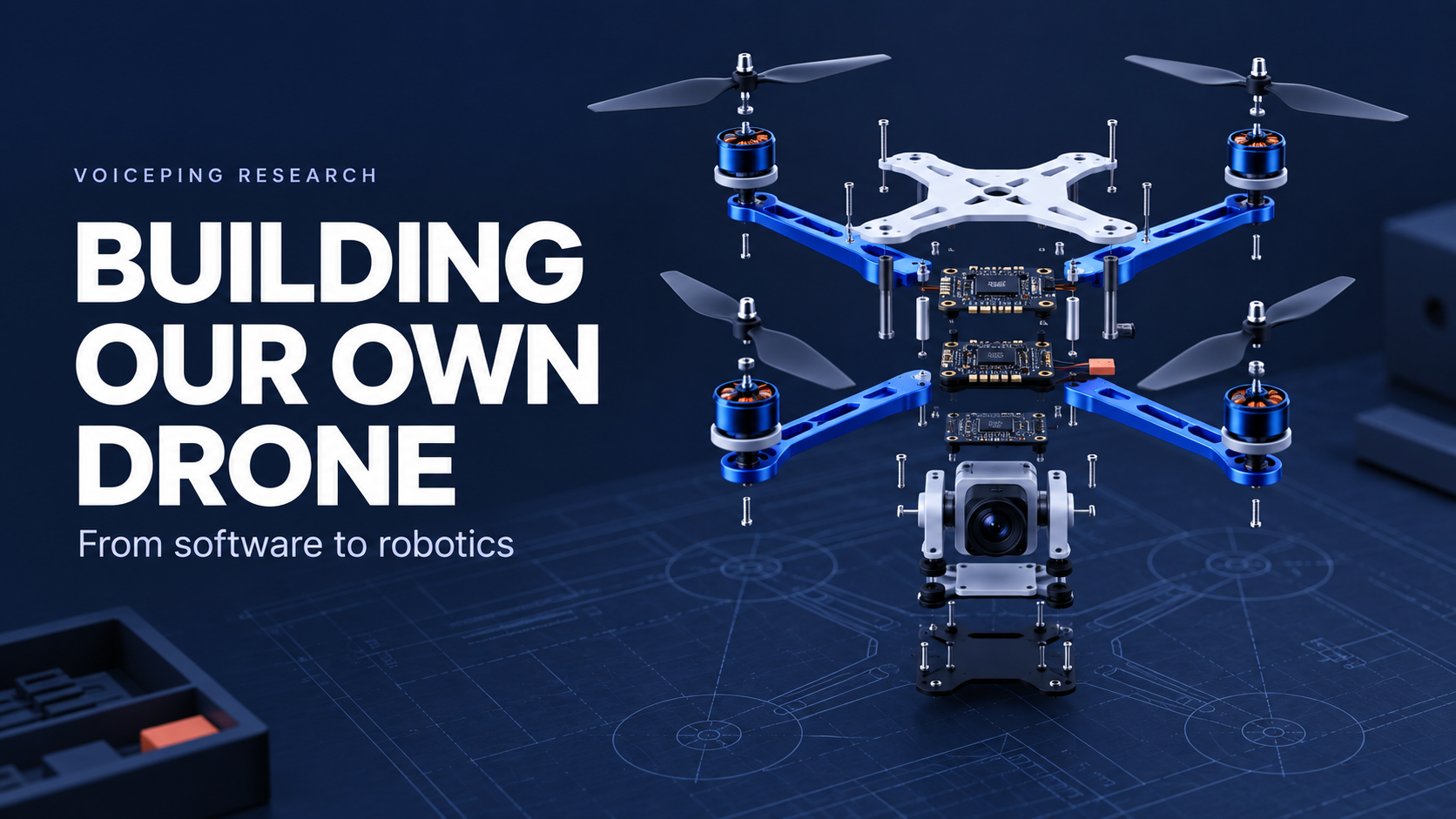
We are building a drone from scratch in-house to investigate that workflow: designing its frame, mounts and integration around commercial flight components and open-source tools. Our intended commercial starting point is a premium professional offering for one narrow task, with close support for capture planning and review. A repeatable, more affordable offering would come later, if the results and customer demand justify it.
Today, we have CAD and print files, a reference hover simulation and offline video-to-3D experiments. Assembly and flight of our own aircraft remain ahead. The use case below defines what we intend to test.
Our first use case: a clearer brief for a specialist
Consider a maintenance team preparing to commission an inspection of selected bridge supports. Before deciding the specialist’s scope of work, they need an initial view of the area: which support is being discussed, what can already be seen and what needs closer access. A photograph without location context or a 3D model with hidden gaps can leave that brief incomplete.
The proposed workflow has a specific input and output:
| Step | What the team would receive |
|---|---|
| Select the question | A named support and the views needed to explain the concern. |
| Gather overlapping views | Images from permitted viewpoints, captured by an appropriate operator; another view requested when a required surface is obscured. |
| Organize the evidence | A spatial overview linked to source photographs, with missing or uncertain coverage explicitly marked. |
| Prepare the specialist’s brief | A human-reviewed record of the area, available evidence and unanswered questions for the next inspection. |
This is a preliminary evidence task. It would not certify structural condition, identify every defect or justify skipping a specialist’s assessment. Our demand hypothesis is that some teams need to do this initial investigation themselves before commissioning a service. Interviews with those teams and the specialists receiving their briefs must establish whether the problem is frequent and valuable enough to solve.
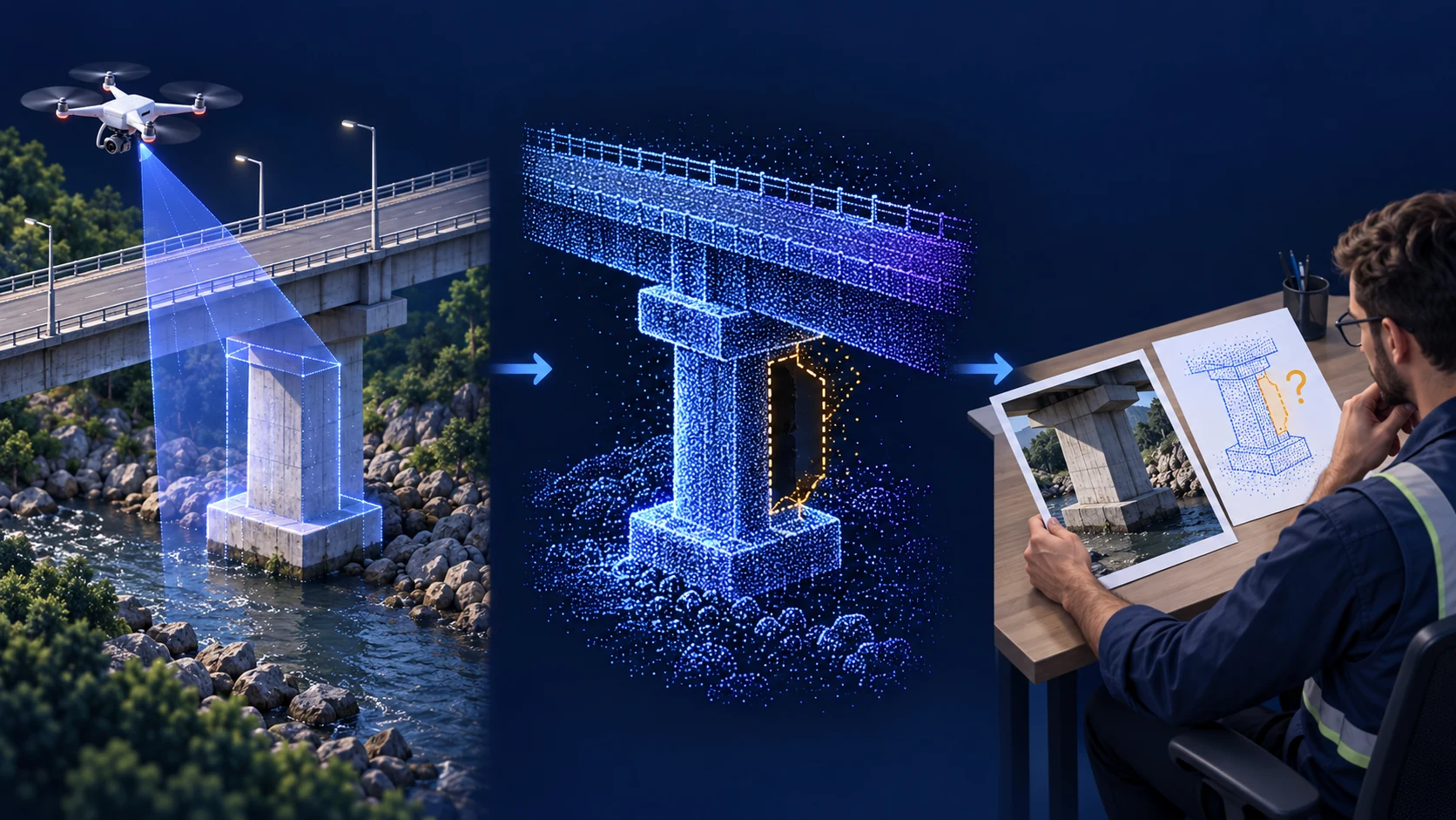
Our first capture tests will use small, controlled scenes. A handheld camera or commercial drone may already provide adequate input; we need to compare those options with the custom platform. Search and rescue in difficult terrain is another possible application, but it requires different reliability, sensing and response arrangements. It is outside this first use case.
Why build a platform we can change?
A drone lets us investigate elevated viewpoints and views across a structure. Flight brings its own constraints: payload, vibration, energy use and the limited time available to gather useful images.
Our small four-inch quadcopter is a platform for studying those trade-offs. Changing the camera position affects both the mounting design and the surfaces it can see. Recording sharper images depends on motion as well as software. Adding a sensor changes weight, power and integration requirements.
Building in-house lets us change those relationships deliberately. We are developing the mechanical assembly and interfaces while using established components for propulsion and flight control. In our planned architecture, a dedicated flight controller stabilizes the aircraft; a Raspberry Pi companion supports camera capture, logging and future mission interfaces. The connection between them still needs integration. ArduPilot’s companion-computer documentation explains this division of responsibilities.
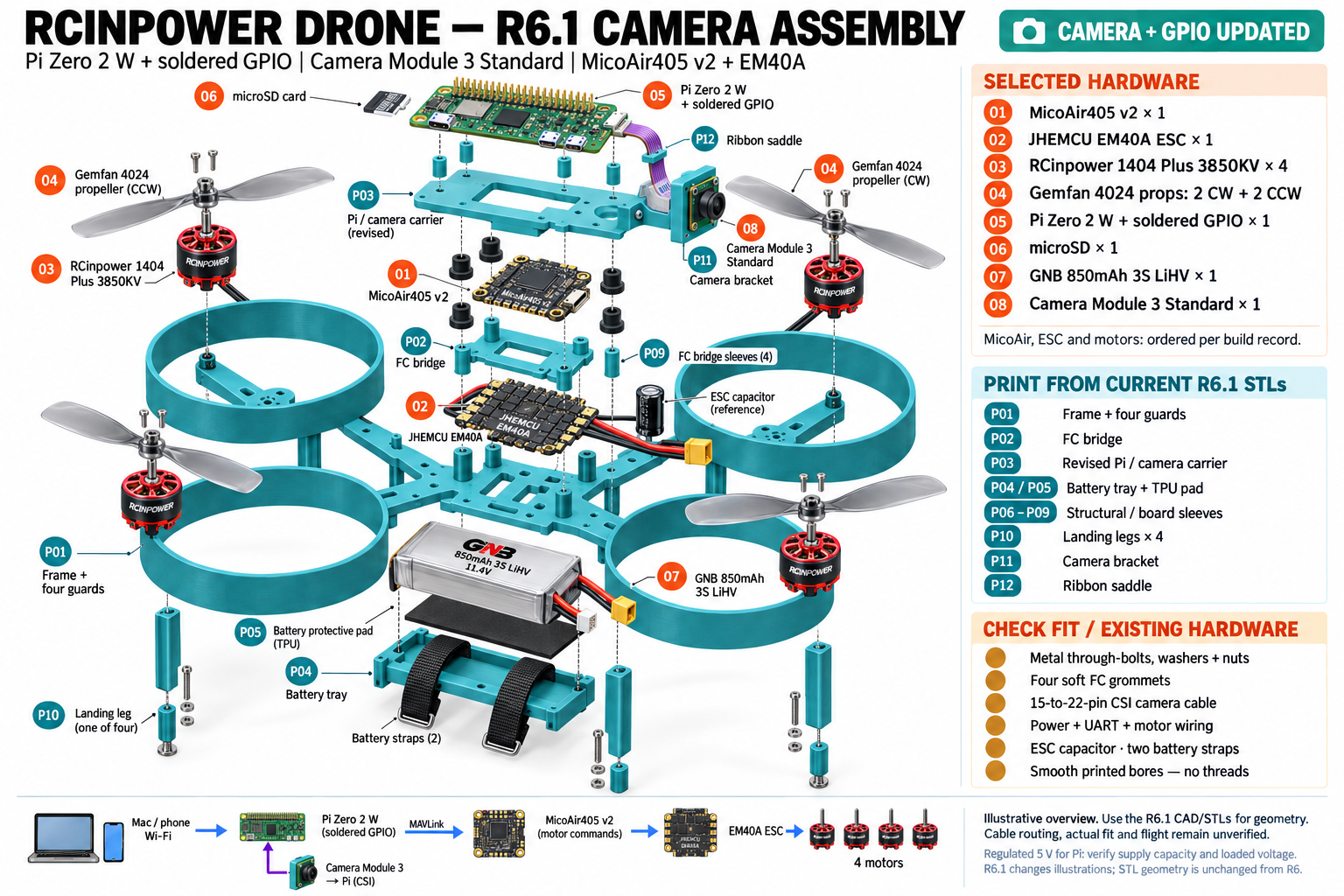
The immediate purpose is a testable research aircraft. Results from this small platform will help us decide which hardware suits a later application, including when an existing commercial aircraft is the better choice.
Building versus buying: what the cost figures cover
Our September 14 parts plan totalled ¥50,214 for flight hardware, a Pi logger, wiring and retention, or ¥80,534 including charging equipment, setup accessories and assembly tools. These are historical planning prices, not recorded project expenditure. The basket predates the current camera-equipped design and excludes the camera, printed parts and final fasteners. A complete cost for the current R9 aircraft has not been established.
| Option and cost reference | Included scope and remaining work |
|---|---|
| VoicePing’s earlier custom-build basket Research and integration ¥50,214 parts; ¥80,534 with charging, setup and tools. September 14, 2026 plan | Flight components, one flight battery, radio/receiver, Pi logger, storage and wiring. The larger figure includes tools that need buying only if not already owned. Camera/cable, printing, final fasteners, shipping, spares, engineering, assembly and validation remain outside it. Itemized historical budget . |
| DJI Mini 5 Pro with RC-N3 Integrated camera-drone reference ¥96,030 displayed promotional price; ¥106,700 also shown. Checked September 24, 2026 | Aircraft and camera, controller, one flight battery and included accessories. A compatible smartphone and separate power adapter are needed. Reconstruction, evidence review, extra batteries, training and operating costs are separate. This package does not include the proposed inspection service. |
| Skydio X10 inspection workflow Professional inspection reference Configuration-specific quote | Define the aircraft, sensors, accessories and required software such as 3D Scan. Obtain a breakdown of licenses, support, training, spares and recurring charges; do not assume they are included in a base aircraft quote. |
The historical basket records tax-inclusive prices and excludes shipping. DJI’s figure is the displayed Japanese-store price; its separate tax treatment was not confirmed in the reviewed product text. These JPY figures use no currency conversion, and prices and availability can change. No professional quote was requested.
The gap between these prices is not a saving. One figure buys an incomplete experimental parts basket, another an integrated camera drone, and the third depends on a professional configuration. The useful comparison is the total cost of delivering the required evidence: equipment, integration, people, software and compute, maintenance, review and repeat capture. We should buy or partner where an existing system serves the task well. Building is justified where control over the experiment produces knowledge we cannot obtain as effectively that way.
From stable flight to useful 3D evidence
The development sequence is straightforward: establish reliable control, capture repeatable images, reconstruct the scene, then check whether the result supports a useful observation. Each step depends on the quality of the previous one.
We have prepared CAD and print files and run a reproducible reference hover exercise in gym-pybullet-drones . That exercise used a small Crazyflie model in ideal simulated conditions. It helped establish a way to inspect trajectories and failed trials; it did not validate our custom aircraft.
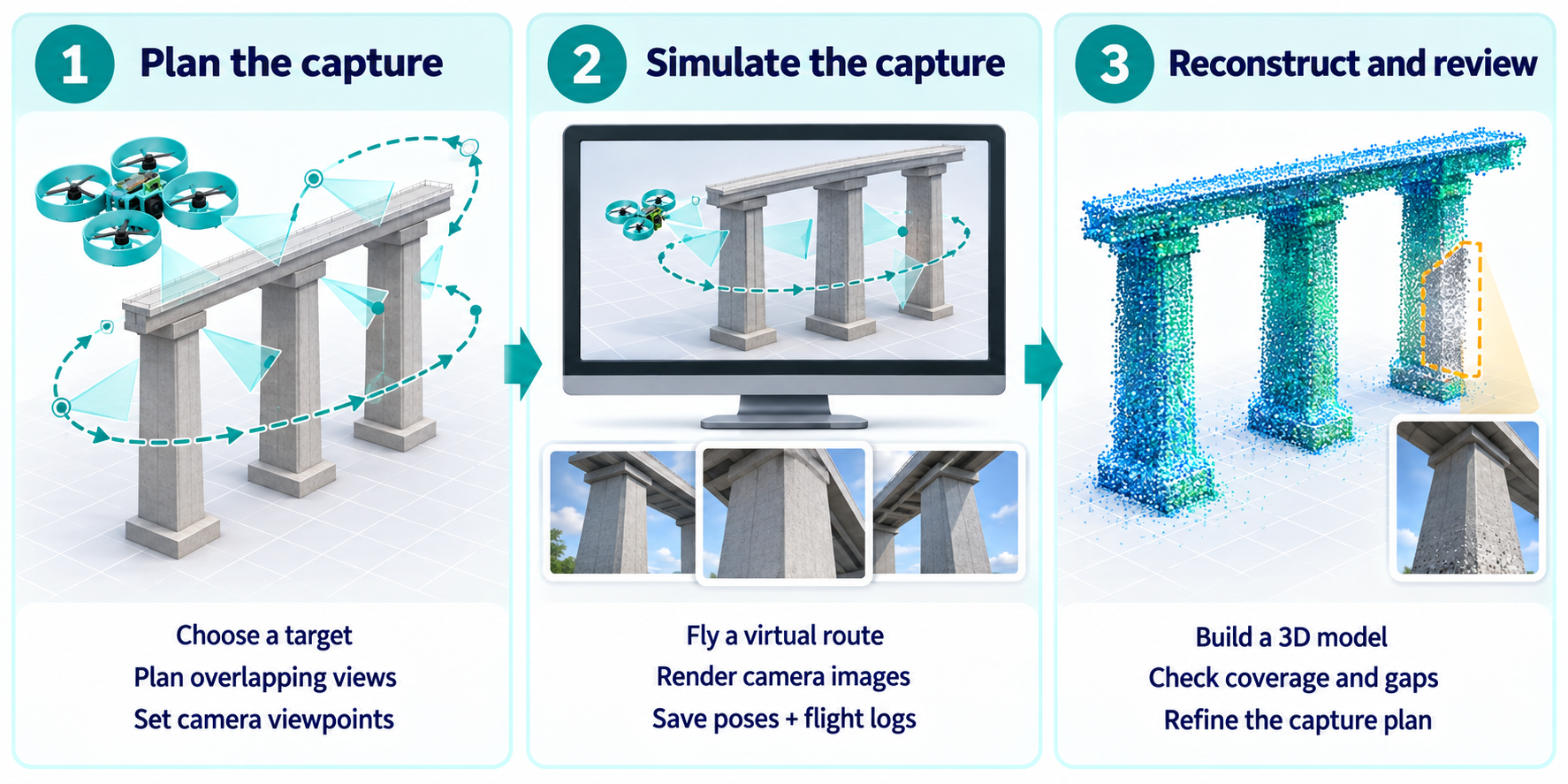
For 3D mapping, the next simulation workflow will connect flight with camera capture: choose a target, render overlapping views along a virtual route, then reconstruct the scene and inspect gaps. The diagram below shows that planned workflow.
We are also testing how recorded images become usable 3D evidence. In a September 17 experiment, we reconstructed construction pillars from 105 frames sampled from a 26.17-second video. This was footage from a moving ground vehicle, used to test the analysis workflow; it was not captured by our drone.
COLMAP registered all 105 frames into one reconstruction. We then gave the same images to a MapAnything Apache checkpoint , which predicted geometry without using COLMAP’s camera estimates as input. The comparison below places both results in a shared display coordinate system.
A fuller-looking reconstruction is not necessarily a more reliable one. MapAnything showed additional pillar faces and surrounding surfaces, but also thickened edges and disconnected fragments. COLMAP left more gaps, while its retained geometry agreed more closely with tracked image features. Processing settings differed, and neither result was checked against surveyed measurements, so this is a workflow comparison rather than a controlled accuracy benchmark.
For our drone, the lesson concerns capture: obtain overlapping views from useful angles, include the surfaces the inspection needs, and check reconstructed geometry against independent measurements. Building the aircraft and camera integration ourselves gives us a way to investigate those choices together.
The research we are using
Our work draws on three foundations with different roles:
| Research foundation | How it informs our project |
|---|---|
| Learning to Fly / gym-pybullet-drones , IROS 2021 | A simulation environment used for our reference control experiment. A model of our own aircraft still needs measured properties and validation. |
| COLMAP , CVPR/ECCV 2016 foundations | Image matching and multi-view reconstruction used as a geometric baseline in our construction-pillar comparison. All 105 input frames registered; measurement accuracy remains unverified. |
| MapAnything , 3DV 2026 | Learned 3D prediction tested on the same construction images. Additional predicted surfaces did not establish better geometric accuracy. |
Simulation also gives us a way to test changes before committing them to hardware. The important transfer is from a documented virtual setup to measured physical behavior. We plan to add aircraft-specific control and capture tests, using physical observations to improve the model. Additional sensors and more autonomous planning should follow demonstrated control and localization needs.
Where we want to contribute in an established market
Commercial drone capability already extends beyond the aircraft. Japan’s ecosystem includes specialist inspection systems, surveying services, remote operations, agricultural equipment and delivery networks.
Recent developments make that clear. Liberaware’s LAPIS integration with TREND-POINT connects 3D processing to construction software. ACSL and Preferred Networks are developing AI-based flight-route generation. Terra Drone’s LiDAR products support aerial and handheld spatial capture. These are existing capabilities and active research areas we need to learn from.
DJI, Skydio and Flyability: commercial products and analysis
The products below are established reference points for drone inspection and mapping. Their documented capabilities were reviewed on September 24, 2026; the comparison is organized by application rather than market-share rank.
| Platform and application | Capabilities and analysis |
|---|---|
| DJI Dock 3 Matrice 4D/4TD + FlightHub 2 Site monitoring and inspection | Dock-based remote operation connects to flight scheduling and route management. FlightHub 2 supports automated 2D/3D model updates, analysis and periodic measurement reports. Dock 3 · FlightHub 2 Analysis: Capture-to-report workflows already exist. Hardware still affects the result: DJI distinguishes the 4D’s mapping capability from the 4TD’s, and FlightHub 2 does not connect other manufacturers’ aircraft. We need to evaluate the complete workflow and its integration constraints. Aircraft FAQ |
| Skydio X10 + 3D Scan Complex-structure inspection | 3D Scan discovers scene geometry and adapts capture paths, proximity and image overlap. Teams can review coverage on site and export imagery for photogrammetry. 3D Scan Analysis: Adaptive coverage is already a product capability. Closer views, greater overlap and stopping for photographs trade flight time and processing effort for detail. These are practical comparison criteria for our own capture experiments. Capture settings |
| Flyability ELIOS 3 Inspector / Inspector Online Japan partner: Blue Innovation Indoor and confined-space inspection | LiDAR-assisted stabilization, live 3D mapping and inspection reporting connect observations to spatial context. Repeat Flight records an initial manual route and capture settings for subsequent automated inspections. ELIOS 3 · Japan product update Analysis: Repeatability and shared inspection evidence are commercial features. Repeat flights still require pilot monitoring, particularly when surroundings change or contain obstacles that LiDAR detects poorly. This sensing approach differs from our current image-only experiments. |
These platforms already connect autonomous capture, coverage assessment, reconstruction and reporting. Generating a 3D model or adjusting a flight path alone would not distinguish our work.
Our intended contribution is a focused preliminary-survey workflow for site teams and the specialists they commission. We want to test whether a question about selected supports can guide capture and human review with less repeated setup. The comparison must measure missing observations, recapture and review effort against existing workflows. Building our own aircraft gives us control over these experiments; the results will also inform whether a later application is better served by an established commercial aircraft.
VoicePing’s software experience also makes the human handover relevant: explaining an observation, reviewing uncertainty and sharing an accepted result. Multilingual reporting may become useful where language is a real obstacle, but customer research must establish that need.
This is a direction to test, not a proven market gap or competitive advantage. The business value would be fewer repeat visits, less manual preparation and more usable inspection evidence. We need comparison with existing workflows and feedback from people who produce and accept those outputs.
Selected industry milestones and videos
These references show the established market around our project. Selected capability and business milestones reviewed on September 24, 2026 are dated individually; older product videos illustrate each company’s work, rather than the milestone itself. Seven entries are Japan-based businesses or groups; DJI is an international platform reference.
ACSL — aircraft and mission planning

Earlier plant-inspection demonstration; separate from the route-generation research. Official video source .
Capability milestone · September 10, 2026: ACSL and Preferred Networks reached the demonstration stage for AI-based flight-route generation. Aircraft integration and representative-environment validation remain later steps. Announcement .
Liberaware — confined-space inspection and 3D data
IBIS2 product footage; the milestone concerns the separate LAPIS software integration. Official video source .
Capability milestone · September 15, 2026: LAPIS integration with Fukui Computer’s TREND-POINT began, allowing LAPIS 3D Core output to load directly into the point-cloud application. Announcement .
Blue Innovation / Flyability — indoor inspection

ELIOS 3 / Inspector workflow from Swiss manufacturer Flyability, presented by Japanese integrator Blue Innovation. Official video source .
Business milestone · September 1, 2026: Blue Innovation signed a partnership with Itabashi Ward for urban drone applications, announced September 2. The agreement starts collaboration; demonstrations and implementation follow. Announcement .
Terra Drone — surveying and measurement

Corporate film; not a demonstration of the two named products. Official video source .
Relevant product milestone · May 13, 2026: Terra Drone launched Terra LiDAR 4 for UAV capture and Terra SLAM TRINITY for handheld capture. The distinction shows why the sensing platform must fit the task. Announcement .
KDDI SmartDrone — remote operations

KDDI’s tunnel-site remote-patrol demonstration using Skydio and Starlink; separate from UTM certification. Official video source .
Business milestone · September 16, 2026: KDDI SmartDrone and NTT DATA became Japan’s first two providers awarded certified UTM service-provider IDs by MLIT, supporting flight-plan coordination. This does not replace individual operating requirements. Announcement .
Aeronext / NEXT DELIVERY — logistics and inspection research

SkyHub ground-and-air logistics explainer; the vessel-inspection work remains under development. Official video source .
Business milestone · September 1, 2026: Aeronext joined Exa’s Physical AI Platform project. Work with Forcesteed Robotics will develop and validate vessel inspection combining drone capture, AI analysis and digital twins. Announcement .
Yamaha Motor — agricultural aviation
YMR-08 footage from Yamaha’s 2019 technical library; a different aircraft from the certified FAZER R models. Official video source .
Certification milestone · September 12, 2025: Five FAZER R-series industrial unmanned helicopter models obtained Class II type certification, announced September 25. This is an established task-specific aviation business. Announcement .
DJI — aircraft, docks and operations software
Dock 3 product footage; DJI is an international reference for integrated enterprise operations. Official video source .
Capability milestone · September 23, 2026: FlightHub 2 added laser-pointed 3D line and area drawing in the Dock 3 Virtual Cockpit, with geometry available as map annotations. Release notes .
Conclusion: the market ahead and VoicePing’s opportunity
Market forecasts point to further growth in drone operations. In its March 2026 report, Impress projects Japan’s drone-services market to rise from an estimated ¥271.1 billion in FY2025 to ¥511.5 billion in FY2030. That category spans inspection, construction and other applications, and includes an estimated value for in-house operations. Impress forecast and market definitions .
Globally, Drone Industry Insights’ May 2026 forecast projects the civil drone market at US$44.4 billion in 2026 and US$83.0 billion by 2035. Its scope includes commercial, recreational and civil dual-use activity. These forecasts describe the wider sector; neither is an estimate of the market for VoicePing’s proposed inspection workflow. Drone Industry Insights forecast .
Visible gaps right now
The sources point to three concrete areas where a new competitor could test an improvement:
- Reliable coverage of difficult structures. A U.S. FHWA project, updated in September 2025, reports that the agency-approved systems it evaluated had difficulty collecting complete condition data around steel bridge beams, trusses and bracing. This is a documented access and coverage problem in that setting. FHWA inspection research .
- Clear evidence of reconstruction reliability. MapAnything’s January 2026 paper identifies an unresolved limitation in handling noise and uncertainty in geometric inputs. Our own experiment also leaves scale and measurement accuracy unverified. A useful preliminary brief must let reviewers trace observations to photographs and recognize what the reconstruction has not established. MapAnything limitations .
- Integration across equipment choices. FlightHub 2 does not connect aircraft from other manufacturers, although it supports third-party algorithms and automated workflows. A team combining different capture systems still needs to evaluate how their records fit together. This makes interoperability a concrete design question; unmet customer demand for another tool remains to be established. DJI FlightHub 2 FAQ .
VoicePing’s reason to enter this market is to make the path from capture to a specialist’s decision easier to trust and less costly to repeat. A new competitor earns its place by improving the required views, the clarity of missing evidence and the work needed to prepare an accepted brief. Those outcomes must be compared with ordinary photographs and existing commercial inspection workflows.
Our aircraft and reconstruction research give us a way to test that proposition; field performance and customer value still need to be demonstrated. We intend to compete on evidence quality, review effort and the total cost of delivering a useful result. Better inspection evidence is the product we intend to compete on.